
“They are taking the furniture to the second floor”: Kurgan and Tyumen regions are expecting floods
[ad_1]
Governor of the Kurgan region Vadim Shumkov called the volume of water that moves into the region colossal. The water is already 10 km from the city. “The water level in Tobol and onlookers walking along the embankment should not reassure you, because most of the water flows through the floodplain,” the governor writes. There is also a threat of flooding in the Tyumen region. MK, together with an expert, looked into the causes of such floods and how they can be prevented.
The governor of the Kurgan region calls for the evacuation of SNT, DNT and flooded parts of the microdistricts on the right bank, as well as houses located up to the dam on the left bank of the city of Kurgan. In Kurgan itself, fences along highways are being dismantled “for the unimpeded passage of water,” the level of dams is being raised, holes are being drilled in the floodplain, sirens are being turned on every two hours, and residents themselves are being asked to remove garbage and liquid household waste before the water arrives.
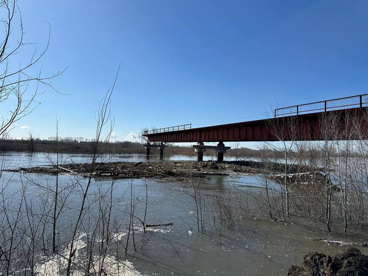
The water level in the Tobol River in the Kurgan area, as of 20:00 (18:00 Moscow time), rose by 10 cm in two hours. The water is at 704 centimeters. The Ural Hydrometeorological Center noted that “on April 15-18, the water level in the Tobol River near Kurgan and downstream will continue to rise, sharply on some days. The water level is expected to exceed the levels of an unfavorable phenomenon (700 cm) and a dangerous phenomenon (850 cm), flooding of coastal areas located within the river floodplain, flooding of floodplain lakes, channels and oxbow lakes.” It is predicted that this flood could be the largest in the last 30 years. Flooding of villages has already begun in the region. In Kurgan itself, embankments, beaches and bridges are gradually flooding. Local residents report that Svobody Street is flooded. Earlier, in the village of Temlyakovo, Kurgan region, a wooden bridge was washed away on the Tobol River, but in the end they were able to catch it.
According to the government of the Kurgan region, as of 10:00 on April 15, 12 thousand 782 people were evacuated. Mostly they stayed with relatives. Temporary accommodation centers were also created. There are 825 people, including 156 children, in the temporary temporary accommodation facility, taking into account those with limited mobility and citizens in need of care housed in medical institutions.
Residents for a long time did not believe the governor’s calls to “immediately leave their homes and dachas.” “Now the water will reach the level of the other bank and go into the field. As it happens every year,” writes one social media user. Under the video of the flood in Kurgan they note: “From this angle you can only see that the Tobol is overgrown and covered in trees and debris.” True, after several photographs and videos of water approaching in different settlements, residents of the region realized that the matter was serious.
A local resident, in a conversation with MK, noted that “the situation is still normal, not critical.” “At the dacha, my grandfather moved all the furniture to the second floor. She plans to return to the city if the water overflows onto the road,” the girl explained.
Floods are also expected in the Tyumen region. There, the water level in the Ishim River is rapidly rising. At the beginning of last week, the water level was 301 centimeters. Now this figure is more than 750 centimeters, with a historical maximum of 835 centimeters. The first flooding is predicted in the village of Ilyinka, and a temporary temporary detention center has already been prepared for residents. In general, the region is actively preparing for the flood: villagers en masse sign up as volunteers, sappers are clearing ice jams on rivers, and Emergency Situations Ministry employees are installing and building up dams.
But what is the reason for such destructive floods? We asked Corresponding Member of the Russian Academy of Sciences, chief researcher and head of the biogeography laboratory at the Institute of Geography of the Russian Academy of Sciences Arkady Tishkov about this. He noted that one of the main reasons is the human factor:
“No matter how much scientists have warned and continue to warn about abnormal floods on rivers, builders still go into the floodplain, develop new territories, sell plots, build, forgetting to insure housing against floods. This is the cause of the emergency. It is not the water that comes to the settlements, but the people, forgetting about the danger, going towards it. Thousands of floods occur on every river, take any section of the floodplain from the source to the mouth of the river. But if there is no housing there, then this is not an emergency. And if a city or village begins to develop a low floodplain, as on the Lena River or the Amur River, then disasters occur. For example, they built the city of Lensk, and there, upstream, due to ice jams, the flow was dammed, the water rose, and the city was washed away. At the same time, there are hundreds of places on the Lena River where the floods are very high, but there are no people or their settlements there. When a person begins to develop a flood plain without protection from floods and, out of stupidity or intent, saving money, for example, begins to build and sell plots of land and housing without insuring it, what happens is what is happening in Orsk, Orenburg and what is now beginning to happen in Kurgan. Today this situation is not only in the Urals. The issue arises, for example, with the lower reaches of the Don River. Everyone thought that it was getting shallow, but here comes the spring of 2024 and the threat of flooding of some areas of Rostov-on-Don and other settlements.
The floodplain, of course, is very attractive for development, economic development, the creation of elite settlements “near the water” and SNT, especially in the steppe regions. But the question of whether to build or not should be decided first of all by hydrologists, who will tell you where the floodplain is flooded every year, where once every 20 years the water can rise by 9 meters, and where once every 100 years – by 11 meters , and therefore cannot be built. A striking example is the Amur River, where in 1983 the urban development of Khabarovsk was severely damaged. Scientists gave appropriate recommendations – where to build and where not to. They clearly identified the floodplain levels that cannot be developed. They didn’t listen! And decades later everything happened again, with billions of dollars in damage to the country, and those responsible were not punished. In these cases, it is not nature that is the enemy and the main negative factor, but man and his mismanagement.”
– How can we prevent this kind of destruction during floods?
– The government flood commission meets annually. I’ve seen this happen several times. Follow her recommendations to protect settlements! The first and most important conclusion: this must be a permanent mechanism with monitoring, control and appropriate conclusions. Secondly, you can follow the principle of the Chinese, who, where everything has already been built up and there is no escape, build powerful protective structures. In large Chinese cities, the river is separated from the entire urban environment by a dam of appropriate height (even ten meters), and thanks to this, there is no serious annual damage. The third is personnel decisions. If a person does not know how to listen to scientists, does not want to turn to academic science or hydrologists from the Hydrometeorological Service, then he does not care about his territory, his city and people. And, of course, we need to stop this mess with the sale of land and construction on low levels of floodplains. Leave it to nature!
[ad_2]
Source link


