
Scientists told about the landfill, where they change riverbeds
[ad_1]
Summer in Russia is a time of natural disasters. Rains flood cities and villages, rivers overflow their banks, flood fertile lands. Floods, floods, multimillion-dollar damage, human suffering – can all this be predicted? It turns out you can!
In the village of Ilyichevo near St. Petersburg, in the former Finnish Yalkala, where V.I. Lenin, there is the Main Experimental Base of the State Hydrological Institute (GEB SGI) with a channel laboratory.
This is a football field-sized hangar filled with various equipment, and in the center is a small river, or rather, a man-made fragment of the river bed, recreated in order to understand the patterns of its flow and solve a number of important practical problems. The MK reporter found out what it is and what it is for.
According to Vladimir Georgievsky, chief researcher at the State Institute of Geography, head of the department of water resources, doctor of geographical sciences, this is an absolutely unique place. There is nothing else like it in the country. “Of course, nature is always more complicated than any models,” says Vladimir Yuryevich. – Modeling a river with its currents and depth differences is not easy. But that’s what science is. When building hydraulic models, scientifically based criteria are used – similarities. Water for the laboratory is taken from the river that flows into Ilyichevo. Recently, we managed to modernize the pump system and update the instrument base.”
Russian specialists from GGI are valued all over the world. They were repeatedly invited to other countries, where they provided methodological assistance in organizing and conducting experimental hydraulic studies. In addition, there is a special metrological pool in Ilyichevo, where hydrometric instruments are verified, including profilographs – systems for measuring the speed of rivers, determining the bottom topography and calculating the volume of river runoff. But the main value of the institute, according to my interlocutor, is people.
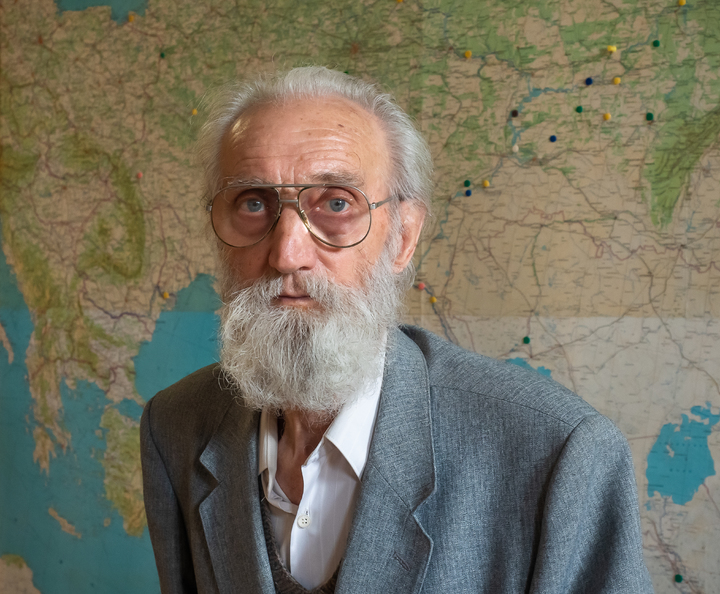
For 65 years, Doctor of Technical Sciences Albert Borisovich Klaven has been working at the main experimental base of the GGI, for 40 of which he was in charge of the channel laboratory. This is the living history of the institute, a person who remembers how it all began.
“I have been working within these walls since 1957,” says Albert Borisovich. – I remember how a young specialist was distributed here after the institute. There was nothing. Bare walls. No equipment. We came up with the idea of using barley as an indicator. They let it into the water stream and thus studied the behavior of river water.
Then they took polystyrene for such studies, a popular packaging material – particles of different diameters. It turned out to be much more convenient. But our first experiments required not only knowledge, but also great ingenuity.
– Why was it necessary to create such a laboratory?
– The need for hydraulic modeling of river sections became obvious by the time hydropower construction began. Hydroelectric power plants were built one after another in the country, and reliable assessments of the possible consequences of building dams on rivers that greatly change the flow regime were required.
Over the past 60 years, hundreds of works of a theoretical, methodological and applied nature have been completed. We have investigated more than 200 sections of different rivers for economic problems. For this, experimental complexes with independent water recycling systems have been created, where there are concrete tanks and pumping stations. This is a complex engineering system that took years of painstaking work to develop.
– What do you think is the most important work in this area?
– In the 1960s, the first model of the Gulf of Finland was created to protect Leningrad from floods. Then it was a real problem. St. Petersburg floods are sung by Pushkin in the poem “The Bronze Horseman”. The construction of the dam solved this problem, although the project had many opponents.
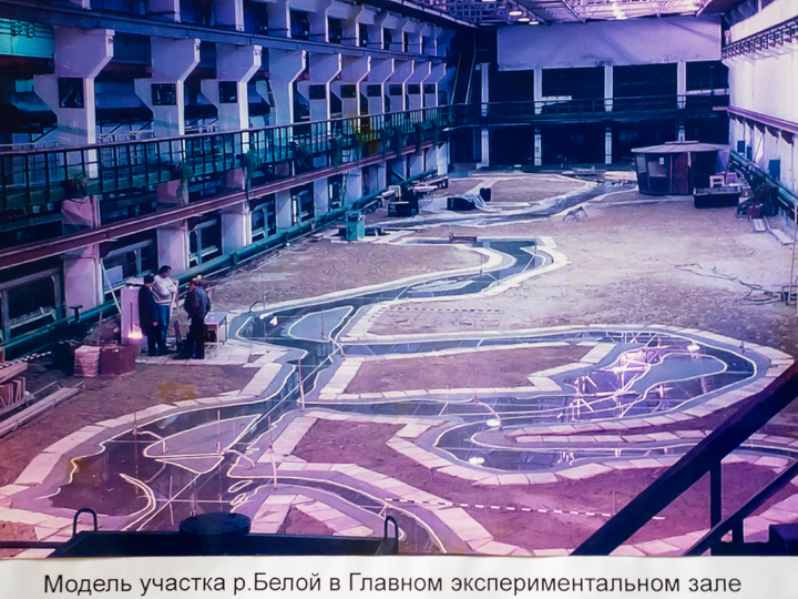
Then a section of the Belaya River was modeled, where it intersects with an oil pipeline. The river is a living organism, it is necessary to take into account all the channel processes in order to correctly lay the oil pipeline. The depth changes all the time, the river flow is turbulent, the pipe after a couple of years is exposed and explodes. To prevent this from happening, our models are needed.
– Were there any unexpected orders?
– Once we were asked for help from the Ministry of Foreign Affairs. On the border with Norway, border posts fell right into the river. I went to the place. I remember standing on the shore, looking around and seeing Norwegian children on the other side. The white ones look at me with curiosity. Children are children everywhere.
In general, I looked around and understood what was the matter. Near the river, the eroded bank is always concave, so all concave banks must be fixed with a stone. This was done, after which the pillars stopped falling. So the problem was solved.
– What kind of model is being created now?
– The current model of the Volga section is made by order of the city authorities of Samara. There, the problem is that the creeping sands close the water intake, and drinking water becomes contaminated with sand. Therefore, we are modeling a section of the Volga in order to calculate how to avoid this.
At one time we solved a similar problem in Barnaul, when the sands from the Ob crawled onto the water intake. When the model was built, both floods and floods were calculated. All this must be taken into account, the nature of the river must be studied in detail, only then can one predict what to expect there. In Barnaul, they sorted it out for a long time, they were transported for several months.
It turned out that channel processes led to the fact that the river was undermining the support of the power line laid through it, sand was washed out from there. We solved the problem with both water and electricity at once, recommending that this power transmission line be mothballed, and another one be installed on the opposite bank. And if the sands come to this shore, open that power line again.
What was the most difficult case?
– Well, for example, a pulp and paper mill was built on the Selenga, and the coast began to “fall down”. We made a model and did the work. There are many branches, the river is not easy. Three years of work – there is no solution. Then they realized that it was impossible to set deep-type installations. It will not work, it will cover with sand, wash away or smash. And so it happened. And you need to make a surface scattering release – there is such a special technology. It is time-consuming and expensive, so at first they didn’t want to listen to us, then they decided to try it anyway – and the problem was solved.
– How can a model, even the best one, repeat the river?
– Of course, any hydraulic model is a schematization of a prototype, where the most significant properties of a natural object for a specific task are reproduced with the greatest possible accuracy. The most common obstacle to the creation of an ideal model is the insufficient size of the laboratory sites. Our job is to minimize possible inaccuracies and create models that most fully reflect all the features of a given river, its dynamics, turbulence, currents, in a word, its special “character”. After all, there are no identical rivers – any river is unique.
– What is required for this?
– To do this, we go to the site and conduct a channel survey of a section of the river, make observations of the water level, measure the speed of the current and water flow, do echo sounding of the bottom … Such work can take more than one summer season, after which we can start creating models on which different options for solving the problem are worked out and, in the end, the most optimal one is selected.
What equipment do you use today?
– Research in the channel laboratory is carried out on hydraulic spatial models of river sections, in the so-called hydraulic glass flumes. Our experimental room for spatial modeling of water bodies with an area of 1500 sq. m is equipped with a variety of technological equipment. This is a hundred-meter hydraulic flume one meter wide with a horizontal bottom and glass walls, equipped with an automatic measuring trolley, hydraulic flumes with the possibility of water supply, as well as measuring equipment, which is represented by both standard instruments and original technological equipment. In general, this is no longer a barley.
– And what kind of hydrophysical laboratory is located in the same building?
– Here began the country’s first experimental work on the study of water migration in the soil, water infiltration into frozen and thawed soils. It was in this laboratory that phenomena were first studied, the mechanism of which was not understood for a long time – the formation in the soil in the spring of the so-called waterproof barrier layer.
Now thermophysical studies are being carried out here, the mechanism of the growth or destruction of the ice cover, the formation of congestion and ice jams is being studied. On the basis of mathematical modeling of heat and mass transfer processes, the mechanism of the influence of climate change on the winter and spring river runoff and the hydrological regime of swamps was revealed here. It has been established that the main factors affecting the increase in winter runoff are a decrease in the depth of soil freezing, which leads to thaws and an increase in autumn soil moisture.
The laboratory is also studying the water absorption capacity of river basins to improve methods for calculating meltwater losses in spring flood forecasts. Our work is difficult, but creative, interesting, and most importantly, people need it.
[ad_2]
Source link


