
Let’s go without satellites – Kommersant
[ad_1]
GPS interference in the center of Moscow persists and continues to seriously affect the work of businesses and the lives of citizens. The problems are most openly recognized by taxi and car sharing services, which had to introduce additional, “manual” location checks. In some areas, the situation is facilitated by the calculation of coordinates using ground equipment. However, so far, experts and market participants note, the scale of difficulties has not reached the level of the emergence of “alternative navigation” as a separate business and popular service.
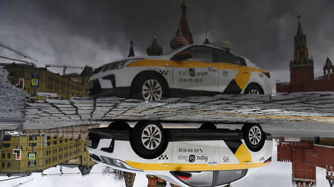
Problems with satellite geolocation in the center of Moscow that followed the drone attack on the Kremlin (see Kommersant of May 4) were not resolved even after the May holidays. The restrictions on renting carsharing in the center, announced by the city’s Department of Transportation at the time the GPS failures began, ended on May 10. However, Kommersant’s correspondents encountered problems when ordering a taxi inside Sadovoye and even the Third Transport Ring even after this date.
On May 16 and May 17, Yandex confirmed the difficulties with geolocation in their transport services: “Due to failures, some taxi users may not display the landing point correctly. Difficulties also arise when determining the location of Drive and Scooters cars in the city center, and the start and end of the lease may be temporarily unavailable.”
Users of GPS-enabled Garmin smartwatches continue to write on w3bsit3-dns.com about problems with recording jogging routes – for example, participants of the Moscow Half Marathon on May 14 faced them, a significant part of which took place inside the Garden Ring and near the Kremlin. Runners reported that the devices incorrectly calculated the length of the route. Difficulties arose not only with Garmin equipment, they were confirmed by users of Amazfit, Huawei, Realme and Asus.
Meanwhile, the authorities did not officially report on the use of means that could interfere with the operation of GPS. The fact that in Moscow, on the eve of the Victory Parade, they will carry out a “change of GPS location,” Baza wrote, citing law enforcement sources. Roskomnadzor says the service “does not have the authority to suppress or distort satellite navigation signals.” The FSB did not respond to Kommersant’s request. A Kommersant source close to the military-industrial complex said that blocking the use of GPS can be carried out with the help of interceptors – devices that suppress signals transmitted from satellites to the ground.
Yandex and BelkaCar, in response to acute problems with GPS, allowed car sharing cars to be booked by license plate, and the Yandex Taxi application asked to additionally check the address of the start of the trip.
One of the Citydrive carsharing users told Kommersant that in the early days of large-scale failures, technical support, apparently, manually corrected the location of cars: “The car was opposite me on Pushkinskaya Square, but it was not displayed in the application. I specified by phone in the technical support of the service that in their system the car was on the Yauza. The operator was able to manually “transfer” the car to the square, and when it appeared on the map, it was possible to book it.” Delimobile and Citydrive declined to comment.
Problems with geolocation on the phone at the beginning of last week were experienced by Kommersant correspondents in Voronezh and Nizhny Novgorod. In St. Petersburg, Kazan, Simferopol, Krasnodar, Samara, Ulyanovsk, Perm, Izhevsk, Pyatigorsk and Makhachkala, there were no difficulties with GPS.
Businesses relying on geolocation, in addition to introducing “manual” methods, have also resorted to reconfiguring the algorithms responsible for determining the location. The fact is that in addition to GPS and other satellite systems (GLONASS, Galileo, Beidou), modern mobile devices can calculate location based on connections to cell towers and nearby Wi-Fi and Bluetooth devices.
All modern versions of mobile operating systems operate with several data sources, says Vitaly Borisov, development director for the Mamba dating app. Recently, he clarifies, Mamba users have not encountered problems with geolocation. The service “relies on mobile OS data sources, and in cases of suspected location spoofing, its own algorithms are turned on.” BelkaCar says that due to problems with GPS, “it was necessary to quickly adjust the methodology of the programs.” “Previously, we mainly relied on satellite data, now we rely on aggregated data from various sources,” the company said.
MTS, which develops fleet management systems and traveling personnel, in 30% of cases relies on geopositioning methods that are alternative to GPS and GLONASS, the company says to Kommersant. They added that devices with radio modules that support multiple satellite navigation systems “give more correct coordinates compared to GPS-only devices.” MTS did not specify how interruptions in GPS operation affected the operation of services, but noted that the algorithms for the operation of the company’s products are “tied to the cellular network.” In VimpelCom, MegaFon, Tele2 did not answer “Kommersant”.
Experts and market participants agree that the services of mobile companies can now become the most understandable and affordable alternative to GPS. But Telecom Daily CEO Denis Kuskov believes that operators are not interested in developing the “navigation” aspect of their business: “Now it is more important for them to invest in communications infrastructure. On navigation services in its pure form, no one earns. Location determination by cell towers, according to the expert, has an error of up to 10 m, which is not enough for transport. It is unlikely that anyone will offer a serious alternative to the classical methods of determination, the Kommersant source on the market agrees. Companies, he said, “expect the resumption of normal operation of satellite systems.” But not everyone can wait.
Navigation of critical situations
It is the ability to jam or fake a signal that leads to the fact that satellite systems are not suitable for critical services, explains Alexei Khripunov, CEO of the Aeroscript Research Center. In air navigation, independent methods are provided when signals from the aircraft are received on the ground, according to the principle of triangulation. This method is considered reliable, “if we ensure the accuracy of the synchronization of the sensors, the correct geometry of the location of the stations and the required number of them,” says Mr. Khripunov.
Navigation problems could not affect passenger airlines, since there are no large aircraft flights over Moscow. In the case of “spreading the geography of stubs outside the city,” says a Kommersant source in one of the large companies, carriers can theoretically notice: “We accept GPS and GLONASS. They operate at very close frequencies, and if something is jammed, then all satellites stop working.” In the absence of satellite signals, the aircraft will fly on the inertial system. Such systems are less accurate, but “the most advanced give a discrepancy of only one nautical mile per hour of flight.”
Logisticians noticed interruptions in geolocation in Moscow – this was reported in the Business Lines Group of Companies. But they assured that there were no problems in the work: “Qualified personnel and modern IT systems hedge risks. In addition, many of our drivers are assigned to specific and well-known areas.” The Russian Post says that it uses both satellite geolocation and “other technologies” to determine the position of cars and couriers, and “has not encountered any problems in work lately.”
[ad_2]
Source link


